Towns & Villages
Local history
East Dunbartonshire is an area of great natural beauty, lying to the northeast of Glasgow. In addition to being the gateway to the West Highland Way and the picturesque Campsie Hills the countryside and its towns and villages are rich in local history and heritage.
Baldernock Parish is remarkable as a quiet, rural, unspoiled area of land, located entirely within a 10-mile radius of Glasgow City Centre. The few lucky people who live there can genuinely claim to dwell in the countryside, and yet they are able to reach the city in the briefest of time, by the shortest of journeys. This was the ideal of the nineteenth century settlers of Lenzie and Bearsden, until those places became so saturated with housing that their rural aspect was forever lost. The same might have happened to Baldernock, for when Bardowie Station was opened in 1905 an extensive housing development was planned, of about 500 commuter dwellings. In the event, only half a dozen or so were built at that time, with a few more in later years, and the local railway was closed to passengers in 1951. The busy traffic in commuters’ cars from Torrance, along the Balmore/Bardowie/Allander road, serves as a reminder of what might have been. All other roads in the parish retain their quiet, rural aspect.
In his Rambles Round Glasgow, published in 1854, Hugh Macdonald wrote enthusiastically about Bardowie Parish. Bardowie Loch he described as ‘Bardowie the Beautiful’ and asked ‘if a glance of it would not more than repay thee for a summer day’s journey’. Bardowie Castle was ‘an edifice of moderate size, somewhat timeworn, yet withal wearing an appearance of quiet cosiness and comfort’. Bardowie Mill was ‘an old and diminutive meal mill’ inactive for want of water at the time of his visit. The former Kirkhouse Inn, beside Baldernock Church, was a ‘comfortable public-house where refreshment of excellent quality for man and beast may be obtained’. Balmore was ‘an excellent specimen of an old-fashioned Scottish clachan’. Nearby he encountered some antiquaries pondering the origin of a square block among the stepping-stones across the River Kelvin. Their idea that it might be Roman was derided by a passing milkmaid who identified it as ‘Redbog’s auld cheese-press’.
Macdonald’s Baldernock can still be recognised and appreciated today. The meal mill at Bardowie has long since been converted to a sawmill, but still retains its waterwheel. The Kirkhouse Inn beside the parish church is now a private dwelling. The stepping stones across the Kelvin at Balmore have been superseded by a footbridge. However, the three giant boulders on Craigmaddie Muir, known as the Auld Wives’ Lifts (shown in picture), can still be visited (with appropriate permissions), as can most of the other parish features mentioned by Macdonald. At Baldernock Church the little stone building at the gate should be noted. This was built for local people to maintain a night watch against the depredations of ‘resurrection men’ (body snatchers) keen to sell practice material to the Glasgow medical schools. The Kirk itself has enjoyed some considerable fame as the setting for Graham Moffat’s famous play Bunty Pulls the Strings, first performed at the Haymarket Theatre, London, in 1911.
Bearsden has been the site of the Parish Church of New Kilpatrick since 1649, when the much larger Parish of Kilpatrick was divided in two. For the next two hundred years and more, "New Kirk", as it came to be known, was no more than a small hamlet, adjacent to the church. During the middle years of the nineteenth century, however, members of the Glasgow business community began to search for suitable localities, reasonably close to the city, to which they could retire each evening from the bustle of city life. They were undoubtedly attracted to Bearsden (or New Kirk as it still was known) because of the acknowledged quality of its natural environment and the prior existence of a parish church to meet their spiritual needs.
The opening of the Glasgow and Milngavie Junction Railway, in 1863, was of fundamental importance. To New Kirk's other attributes could now be added a "fast track" home for commuters each evening. The local station was given the name "Bearsden", and this soon succeeded "New Kirk" as the name of the adjacent community. The name Bearsden was taken from a house close to the station site, but it seems also to have been a locality name, of wider application. Its origin has been the subject of much investigation and debate, all of it lacking in satisfactory conclusion.
During the twentieth century Bearsden has expanded and developed in a more comprehensive and rounded way than many of the other commuter satellites of Glasgow. In addition to large villas, of individual design, big estates of bungalows and other private house types have been laid out, so that few sites are now left unoccupied. A significant early twentieth century development was the creation of Westerton Garden Suburb, from 1913 onwards, as Scotland's first project of this type. The identity of Bearsden was greatly strengthened in 1958, when it achieved burgh status. The Burgh of Bearsden has since been succeeded, as a local authority, by Bearsden & Milngavie District Council (1975) and East Dunbartonshire Council (1996).
Bishopbriggs shares certain elements of its history with Kirkintilloch and others with Lenzie. Like Kirkintilloch it was a roadside village on a major highway from Glasgow to the east, the line of which is preserved by Crowhill Road, and the 'Low Road' north of Bishopbriggs Cross (less clearly seen since the building of The Triangle). Like Lenzie it enjoyed the benefit of a railway station from 1842, when the main Edinburgh and Glasgow Railway was opened. As at Lenzie, free "villa tickets" were granted to persons building large houses near the station during the 1850s (in Springfield Road).
Unlike Lenzie, however, Bishopbriggs also had a fairly large working-class population during the nineteenth century, employed in the extensive quarries at Crowhill, Huntershill and Kenmure, which provided the City of Glasgow with sandstone for its tenements and other buildings. The workers were housed in tenements at Colston and in the rows known as The Diggings close to Bishopbriggs Cross. Later, a significant working population was employed at Cadder Colliery and housed in miners' rows at Mavis Valley and Jellyhill.
During the twentieth century Bishopbriggs reasserted itself as a desirable place of residence for Glasgow commuters. Large villas were built in Kirkintilloch Road, around the turn of the century, and there was further significant construction of private housing during the Inter-War period (although a planned "Garden City" at Cadder did not then develop as intended). It was only during the 1950s and 1960s, however, that population growth took place on a large scale, with the creation of extensive residential estates. The resultant demand for autonomy of local government led to the establishment of the Burgh of Bishopbriggs, which lasted from 1964 until the Local Government Reorganisation of 1975. Local residents then successfully campaigned to be excluded from the new City of Glasgow District, and Bishopbriggs was instead located with Kirkintilloch , Lenzie and other towns and villages in Strathkelvin, for the next twenty-one years. Since 1996 Bishopbriggs has been part of East Dunbartonshire.
Campsie (encompassing Lennoxtown, Milton of Campsie and Torrance)
The old parish church and graveyard have often fascinated visitors to Campsie.
Campsie Parish was originally associated with the old Church of St Machan, first established at Campsie Glen during the twelfth century, beside the reputed grave of the saint. The parish church was moved to Lennoxtown in the 1820s, but remains of the older church can still be seen in the graveyard at the Clachan.
Campsie Parish has some interesting placenames. At one time there was a 'Kirktown of Campsie' at Campsie Glen, beside the parish church, a 'Newtown of Campsie' at Lennoxtown, where a new town was built during the late eighteenth century to accommodate workers employed in new industries there, and a 'Milltown of Campsie' at Milton, where there was a mill. The significance of this is only slightly diminished by the fact that the mill at Milton was not the principal parish mill, which honour belonged to Lennox Mill at Lennoxtown.
During the late eighteenth century and throughout the nineteenth Lennoxtown was the focus of flourishing industrial development, based on the mining, textile printing and chemical industries. This was in sharp contrast to the scenic beauty of the surrounding area, epitomised by Campsie Glen, renowned as a tourist attraction. Down to the end of the eighteenth century it was inaccessible to visitors, but then it was thrown open to all by the local landowner, John McFarlan of Ballencleroch, who by doing so gained great popularity with the local people. The great beauty of the Glen and the hills above continues to be appreciated by the many visitors to the area each year.
The Clachan
One of the most beautiful places in East Dunbartonshire is Campsie Glen, near Lennoxtown, with its adjacent village, known as the Clachan of Campsie.
The Clachan is a designated conservation area. It is important that visitors to both village and glen respect this and do not leave litter or cause any damage.
A wander round the village has much to offer, with some features worthy of special attention.
Schoenstatt Retreat
Schoenstatt Shrine Set in its own extensive grounds, this purpose built Retreat and Conference Centre is run by the Schoenstatt Sisters of Mary and offers the perfect setting to reflect, and find peace and tranquillity. The Shrine dedicated to Our Lady of Schoenstatt has become a place of pilgrimage for thousands of people each year. The adjacent Ballencleroch House can accommodate up to 32 guests in 15 twin-bedded and two single rooms - all with en-suite.
The Shrine and House are open throughout the year, with the grounds providing pleasant walks suitable for the disabled. At Ballencleroch House you are assured of receiving a warm welcome and enjoying a peaceful and relaxing time.
Old St Machan's Church
The Clachan Church and Graveyard (shown), in their picturesque setting, have always been a major attraction for visitors to Campsie Glen.
The church took its name from St Machan, who brought Christianity to Campsie during the Dark Ages. After travels to Ireland and Italy, he erected a small chapel at the foot of the Glen and used an adjacent well for baptisms.
On his death, he was buried at the site and the first parish church was erected over his grave around 1175.
The Clachan Church survived many alterations over the years, with the last substantial re-build in the 1770s. Not long after its abandonment in 1828, it was decided to take down most of the old building to raise money from the fittings.
During the 1850s the bell tower was still complete and the bell continued to be rung for funerals and for Sunday evening meetings at the parish school nearby.
Shortly afterwards this practise was stopped and the bell removed, first to the Oswald School in Lennoxtown and then to Milton of Campsie Church, which opened in 1888.
Parish School
The old parish school can be seen on the left-hand side of the road into the Clachan. The original school was erected in 1661, under the patronage of John, Archbishop of Glasgow, and the deed of erection stipulated that the schoolmaster "in all time coming" should teach Latin.
The school was operational until June 1978, when the building ceased to be used for its original purpose. However it is still worth a look when you are in the village.
The Red Tub Tearooms
Formerly the Crown Inn, the Red Tub Tearooms were opened in 1922. They were run by a group of well known local ladies.
Between 1936 and 1938 the Red Tub was used as a training centre by the world champion boxer Benny Lynch. This introduced a new attraction to the Glen and thousands flocked to the Clachan in the hope of catching a glimpse of their hero.
When the Tearooms finally closed, the building became a private dwelling, and changed its name to Aldessan House. It was occupied by the postmistress for a period and the adjoining shop converted into a sub-post office and shop.
The Aldessan Gallery, Clachan of Campsie
This closed during the 1970s and the building lay empty for a number of years, before being renovated in the mid-1980s. On Friday May 6th 1988 it was re-opened as the Aldessan Gallery - a craft shop and tearoom still in operation today and well worth a visit.
The East Dunbartonshire communities of Lenzie and Bearsden share a common history. Both were developed around their railway stations during the second half of the nineteenth century, to meet the aspirations of members of the Glasgow business community who wished to live in a pleasant country environment close enough to fast-track to their work in the city each day.
Lenzie began to develop earlier than Bearsden. The first three "commuter houses" were built in Auchinloch Road, just south of the station in 1848. During the 1850s the Edinburgh and Glasgow Railway Company encouraged the development of houses beside its railway stations by offering free season tickets to persons building villas worth £500 or more.
Duration of the tickets was on a sliding scale, with each £100 of the value of the villa being worth one year of free travel. However, comparatively few commuters took up the offer at the time, mainly because of a shortage of amenities near the stations. In Lenzie large scale development began in the 1870s, when running water was piped in for the first time.
Bearsden Station was opened in 1863, and at first development was slow. As at Lenzie, however, the 1870s was a period of major growth, thanks to the introduction of a supply of running water. Most commuters walked to the railway station, but by the end of the nineteenth century a few of the outlying residents were employing a coachman, coach and horses to take them to the railway each morning and to wait for the arrival of the business train from the city each evening.
Milngavie had a range of local industries to provide employment for its residents and did not at first jump on the commuter bandwagon. From the 1890s, however, a number of houses aimed at the Glasgow business market were erected, especially in the vicinity of Tannoch Loch.
A boom in commuter traffic soon led to the enlargement of Milngavie Station and doubling of the railway line to Westerton.
Kirkintilloch was a place of importance in Roman times, when a fort was established there on the east-west barrier across Scotland, nowadays known as "The Antonine Wall". This was constructed around 142AD as a boundary line between Roman civilization and wilder territory not under permanent Roman control. For a short period it replaced the more southerly "Hadrian's Wall". The departure of the Romans was followed by a Dark Age when little is known of Kirkintilloch's history, although the name "Kirkintilloch," in its original form of Caerpentaloch "The Fort at the Head of the Ridge," dates from this period. Light began to dawn again during the twelfth century, when the prominent Comyn family established a castle in central Kirkintilloch, with a parish church to the south (at the locality now occupied by the Old Aisle Cemetery). The Burgh of Kirkintilloch was created in the year 1211, (although it was 1938 when an official grant of arms was granted by the Lord Lyon ) and a local market was held weekly thereafter.
In medieval times Kirkintilloch was situated on an important highway between Glasgow and the east, and indeed the town's axis lay very much on an east-west alignment at that time - West High Street, High Street and Eastside. A bridge over the Luggie was established at an early date, and was of vital importance in keeping the highway open in bad weather. The parish church was moved from the Old Aisle to central Kirkintilloch in 1644. Improved transport links in the form of the Forth and Clyde Canal (1773) and the pioneer Monkland and Kirkintilloch Railway (1826) led to the establishment of important new industries - cotton, weaving, Iron Founding and boat building. During the twentieth century these all faded away, but there was an attempt to replace them with new ones during the period of Glasgow Overspill, around 1960. This met with only limited success, but the Overspill project resulted in the construction of many homes, both in the rented and private sectors, with a consequent increase in the population of the ancient burgh.
The Auld Kirk at Kirkintilloch Cross dates from 1644 and is one of Kirkintilloch's oldest buildings. Until 1914 it served as the parish church, but in that year the new St. Mary's Church was opened at the other end of Cowgate, to take its place. The Auld Kirk was then used as a Sunday School. Since 1961 it has been the town museum. The nearby Barony Chambers was erected in 1814-15 and formerly served as the town hall, council chambers, court house, school and jail. Today it serves as offices for East Dunbartonshire Leisure & Culture Trust's Museum Service.
Have you ever wondered about the history behind the Old Aisle Cemetery Watch-Tower in Kirkintilloch? Check out a new leaflet on the building, which benefited from works as a result of funding from Historic Environment Scotland.
On 2 October 1211, King William the Lion granted the liberty of a burgh at Kirkintilloch to William Comyn. The Comyn family established a castle in central Kirkintilloch at Peel Park, with a parish church to the south (at the locality now occupied by the Old Aisle Cemetery). This meant that Kirkintilloch became only the second burgh of barony in Scotland (after Prestwick) to be created as such, though there were about thirty royal burghs in existence by that date. The original charter has long been lost, but a sixteenth century notarial copy survives.
The Latin text:
Concessio liberates burgi apud Kirkintulloch
Willielmus Dei gratia Rex Scotorum omnibus probus hominibus totius terre sue clericis et laicis Salutem. Sciant presentes et future me concessisse et hac presenti carta mea confirmasse Willielmo Cumyng et heredibus suis vt burgum habeant apud Kirkintulloch et forum per diem Jouis cum libertatibus et rectitudinibus ad burgum pertinentibus ita libere et quiete et honorifice sicut aliquis baronum meorum burgum habet ex dono meo in terra meo. Testibus Alanao filio Ronaldi constabulario meo, Willielmo de Boscho cancellario meo, Philippo de Valeniis camerarioo meo, Philippo de Mowbra, Alexandroviceco mite meo de Stiruiling, Harberto de Camera, Adam filio eius. Apud Foresi secundo die Octobris.
Et extractum de registro decani canonicorum et capitulj ecclesie metropolitane Glasguensis per me Richardum Harbertsoun notarium publicum ac scribam dictj capitulj pro tempore teste manu propria RH
Ita est Richardus Harbertsoun notarius publicus ac scriba dictj capitulj vt supra manu sua RH
Ita est Robertus Blair notarius publicus et conotarius in coroborationem subscriptionis notarij prescripti per eum requisitus teste manu propria RB
The translation:
Grant of the liberty of a burgh at Kirkintilloch
William, by the grace of God, King of Scots, to all honest men of his whole realm, clergy and laity, greeting. Let those present and to come know that I have granted, and by this present charter confirmed, to William Cumyng and his heirs that they should have a burgh at Kirkintulloch, and a market upon the Thursday with the liberties and privileges belonging to a burgh, as freely and as undisturbed and as honourably as any of my barons have a burgh from me as a gift within my realm. Witnesses, Alan, son of Ronald, my constable, William de Boscho, my chancellor, Philip de Valeniis, my chamberlain, Philip de Mowbray, Alexander, my Sheriff of Stirling, Harbert de Camera, Adam, his son. Given at Forres, the second day of October.
And extracted out of the Register of the Dean, Canons and Chapter of the Metropolitan Church of Glasgow by me Richard Harbertsoun, Notary Public, and Clerk of the said Chapter pro tempore, witness my hand. RH
Ita est, Richard Harbertsoun, Notary Public and Clerk of the said Chapter, as above mentioned. RH
Ita est, Robert Blair, Notary Public and Co-Notary in corroboration of the subscription of the before written Notary by his request. Witness my proper hand. RB
Of fundamental importance was the liberty to hold a weekly market. It can be accepted that Kirkintilloch was a market period from this time onwards. The charter is dated 2 October, but no year is given. The question of the year was for long a matter of great controversy. In 1894 Thomas Watson commented that “most writers give 1170 as the year, and others of 1184, but on what grounds we are unable to discover.” In 1910, John Horn felt confident to state that the charter “was granted by King William the Lion in 1170, or thereabout.” In 1937 Thomas Johnston ventured that the charter dated from the “some year at the end of the XII century”. Then, in an article in the Scottish Historical Review of April 1950, Professor G.S. Pryde convincingly argued that the charter should be assigned to the period 1211-14, right at the end of William the Lion’s reign. He pointed out that William de Boscho was not appointed Chancellor until June 1211. To be on the safe side, Kirkintilloch Town Council decided to celebrate the 750th anniversary of the burgh in 1964, the latest possible year. It now appears that they were over cautious. In his edition of The Acts of William I, published in 1971, Professor G.W.S Barrow confidently assigns the charter to the year 1211, the given reason being that “William Cumin had become Earl of Buchan by August, 1212."
The attached map shows the Barony Burgh boundaries (in green) and the Police Burgh boundaries (in red). It is a copy of the Second Edition Ordnance Survey map of 1899 which has been hand coloured and annotated by the Kirkintilloch Burgh Surveyor, William Marshall.
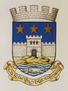
Azure, a wall towered and embattled Argent , port sable, standing upon a mount proper; in chief three stars of five points Or, and in base in a stream a fish naiant proper"
Although established as a burgh in the 13th century, Kirkintilloch received an official grant of arms from the Lord Lyon in 1938. The heraldic description is quoted above.
The wall towered and embattled represents the Antonine wall and Roman Fort, the three stars symbolise the holy trinity and the fish represents trout in the rivers Luggie and Kelvin.
Under the shield is placed the motto, Ca'canny but Ca'awa which was translated as Progress with vigilance when adopted by Strathkelvin District Council in 1975.
Carry on carefully, but keep carrying on is thought to refer to the advice an expert weaver may give to a novice weaver when working a hand loom.
The focus of the Lennoxtown area, in former times, was the busy Lennox Mill, where tenants of the Woodhead estate brought their corn to be ground. There were several corn mills in Campsie Parish, but this was arguably the most important. Lennox Mill was located near the site of the recently demolished Kali Nail Works.
A significant event in the history of the locality was the opening, during the late 1780s, of the calico printing works at Lennoxmill, on a site adjacent to the old corn mill. Calico is a type of cotton cloth, and the printing of cotton cloth was soon established as a major industry in the area, also at Milton of Campsie. It was to provide accommodation for the block makers and other cotton printing workers that the village of Lennoxtown was established, during the late eighteenth and early nineteenth centuries. Streets of houses were planned and built according to a formal plan. Lennoxtown was at first known as ‘Newtown of Campsie’, to distinguish it from the ‘Kirktown’ or ‘Clachan’ of Campsie, at the foot of Campsie Glen.
During the nineteenth century Lennoxtown grew to be the largest centre of population in Campsie Parish. Another important industry was soon established, namely a chemical works, by Charles Macintosh (of waterproof clothing fame) and his associates. At first the principal product was alum, a chemical employed in the textile industry. Alum schist, the basic ingredient in the process, was mined in the area. The works came to be known as the ‘Secret Works’, presumably because of the need to keep the industrial processes secret.
During the 1790s many of the Lennoxmill workers supported Thomas Muir of Huntershill in his campaigns to establish democracy in Scotland, and a Reform Society was set up in Campsie in 1792. However, the parish minister, the Rev. James Lapslie, saw to it that there was also some opposition to Muir’s ideas in the area. An important milestone in the drive towards democratization was the establishment of a local co-operative society, the Lennoxtown Friendly Victualling Society, one of the earliest of its kind in Scotland, in 1812.
The growing importance of Lennoxtown was underlined by the removal of the Parish Church from the Clachan to the ‘New Town’ during the 1820s. Plans for the new church were prepared by David Hamilton, a well-known Glasgow architect. A Roman Catholic Church was erected in 1846 (originally St Paul’s, later renamed St Machan’s), one of the earliest post-Reformation Catholic churches in Scotland, apart from those in cities and large towns.
The decline of the industries that flourished during the nineteenth century, and also the later nail-making industry (and indeed the famous Victualling Society) has left Lennoxtown in a kind of post-industrial limbo, from which it has been difficult to escape. However, progress continues to be made, and many people have found the foothills of the Campsies at Lennoxtown an attractive location to set up home.
Lenzie Junction Station in former years.
Lenzie The station opened in 1842 but Lenzie was not fully established as a centre of population until piped water arrived in the 1870s.
The name "Lenzie" is very old indeed, although the same cannot be said of the place that now bears it. The original Lenzie was an ecclesiastical parish that extended from Kirkintilloch south-eastwards as far as Cumbernauld. The lands of Lenzie were for many years possessed in their entirety by the Comyn family, who build a castle in Kirkintilloch. The name was pronounced "Lingie" at that time, and for many years thereafter.
The history of modern Lenzie can be traced back only to the year 1842, when the Edinburgh and Glasgow Railway was opened and a station established there to serve the town of Kirkintilloch. The building of houses for Glasgow commuters, close to the station, began about 1848 and was given impetus by the railway company's scheme of the 1850s to offer free season tickets to persons building large villas near any of its stations.
However, large-scale construction did not begin until piped running water was made available to the villas during the 1870s, by which time the free "villa tickets" scheme had been discontinued. The housing and population boom of the 1870s is reflected by the fact that all three of Lenzie's main churches - the Old Parish, the Union and St Cyprian's - were established during that decade. The growth of Lenzie as a convenient place of residence for Glasgow commuters has continued ever since.
The railway station was opened to serve the town of Kirkintilloch, and was accordingly named "Kirkintilloch" at first. During the 1840s it was relocated to Garngaber, for a short period. In 1848 it was moved back to its present site, and with the opening of a branch to Lennoxtown it was renamed "Campsie Junction." The extension of this branch to Campsie Glen and beyond, in 1867, rendered the name anomalous, and the railway company (by then the North British) chose the old parish name of "Lenzie" to replace it. The station and its environs have been known as Lenzie ever since (although pronounced differently from the old parish).
The town of Milngavie (pronounced 'mill-guy') is in the former Parish of New Kilpatrick, created by the division of the old Parish of Kilpatrick in 1649. Although most of the parish was in Dunbartonshire, Milngavie was for many years in Stirlingshire. The anomaly was removed in 1891, with the transfer of Milngavie to Dunbartonshire. The town was by then a police burgh, a status achieved in 1875. A great deal of interest has centred on the origin of the name "Milngavie," partly because of the unusual pronunciation. The "Miln" is undoubtedly the town's familiar mill on the Allander, but agreement has yet to be reached on the latter part of the name (should it be 'Gavin' or 'Davie'?).
In former times Milngavie was notable for its variety of industry. At different times, over the years, there was a linen mill, bleach works at Clober, Craigallian and Craigton, a calico printfield near the site of the present railway station, a distillery at Tambowie, and a dye works at Burnbrae, while on a site just north of the town centre there was a cotton mill and later a paper mill.
The local Mugdock and Craigmaddie reservoirs, fulfil an important role in the supply of water to the city of Glasgow.
With the decline of its traditional industries, Milngavie has acquired a reputation similar to that of Bearsden, as a pleasant place for members of the city business and professional community to establish their homes. Milngavie station was opened as long ago as 1863, yet the local railway still fulfils its intended purpose of transporting large numbers of local people into the city each day.
Milton of Campsie (or ‘Milltown’, as occasionally spelled) is thought to be a comparatively modern name, although some of the local mills were hundreds of years old. There were at least three corn mills near the village, all attached to large estates, namely Glorat, Lochmill (for Antermony Estate) and Frenchmill (for Kincaid). There were in addition at least two other mills, both lint mills for the processing of flax for the linen industry. Perhaps it was Frenchmill, very close to the village, that gave rise to the ‘Milton’ name, although this is unclear.
A great leap forward took place in 1786, with the opening of a calico printing works at Kincaid. This signified an important change in the local textile industry, from linen to cotton. Kincaidfield, as it was known, was soon providing employment for a large number of workers, and the village of Milton began to grow significantly in size.
A second printfield was opened at Lillyburn during the 1790s. It was converted to a whisky distillery in 1826, but soon reverted to calico printing. Throughout the nineteenth century the local textile printing industry continued to flourish, but Kincaidfield closed in 1901 and Lillyburn in 1929. The works at Kincaid was demolished, but Lillyburn was converted to a pulp packaging manufactory, which eventually closed during the 1980s.
Milton of Campsie derived great benefit from the opening of a centrally-placed railway station in 1848, on a branch line built during that year from a junction on the Edinburgh & Glasgow Railway, at Lenzie, to Lennoxtown. It served the village well for over a century, until closure in 1951, by which date, road transport options had been greatly improved. Visitors to Milton today should perhaps make a point of visiting Kincaid House, the ancient seat of the Kincaids of that ilk. So much of Milton’s history is closely linked to that of Kincaid. It was the Kincaid estate mill at Frenchmill that seems to have given the village its name, and it was on the Kincaid estate during the 1780s that the calico printing industry, so important to Milton’s economy during the nineteenth century, was first established.
The owner of Kincaid estate during the 1830s, John Lennox Kincaid Lennox, inherited nearby Woodhead and combined the two estates. He built Lennox Castle to serve as an appropriate dwelling for the inheritor of extensive landed property.
When in the Lillyburn area, visitors should remember the important McNab family who once owned the calico printing works there. Alexander McNab (1819-97) was responsible for the supply of gas and running water to the village of Milton and provided funding for the building of a public hall, in 1887. His framed portrait can be seen at the hall, in Craighead Road. Another significant local family, the Stirlings of Glorat, still own the Glorat Estate.
The village of Torrance is situated in a local area known for centuries as ‘The Eleven Ploughs of Balgrochan’. The Eleven Ploughs were part of the estate of the Grahams of Mugdock (Milngavie). They received their name in 1630 when Montrose, the great military leader of the Covenanting period, sought to raise money for his campaigns by feuing off part of the Mugdock lands. The ‘Eleven Ploughlands’ were feued off to local occupiers willing to pay a grassum (lump sum) on the understanding that their annual rate of duty would be held at a moderate level. Three of the Ploughlands were at Carlston, four at Easter Balgrochan and four at Wester Balgrochan.
“The eleven ploughs o’ Balgrochan were acquired at that time
By eleven sturdy carles, as they ca’ed them lang syne”
The feuars originally held their land in run-rigs, running down in long strips southwards to the River Kelvin. In 1735, however, each feuar received an enclosed piece of land, in line with the widespread drive towards land enclosure at that period. Coal and lime continued to be worked in common, but ironstone rights were allocated to individual ploughland proprietors.
Some time after the enclosures of 1735, the village of Torrance began to develop. Some of the earliest inhabitants were ‘country weavers’, weaving linens or woollens in association with local farming activity. Around this time, also, the extraction of limestone, coal and ironstone began to emerge as a local industry of some significance. During the late eighteenth century the improvement of local roads and the opening of the Forth & Clyde Canal, with a wharf at Hungryside, provided routes to market for local agricultural and mineral production.
When the Eleven Ploughs were feued off by Montrose in 1630, the large meal mill at Balgrochan was at the same time feued to a Robert Ferrie. Three hundred years later the mill was still grinding corn and celebrating three centuries of Ferrie family ownership. In 1933, however, it was closed and sold to a Glasgow firm for the manufacture of talcum powder. The mill wheel at Balgrochan was said to be the second largest in Scotland. It was cut up for scrap in 1949.
The canal wharf at Hungryside remained for many years as Torrance’s principal link with the outside world. In 1879, however, a station was opened at Torrance by the Kelvin Valley Railway Company and the village, somewhat belatedly, was linked to the national rail network. It might have been thought that Torrance would then have developed as a commuter dormitory for Glasgow, but the influx of new residents was slow in arriving. Indeed it was not until after the railway was closed to passengers in 1951 that commuting began in earnest. During the mid-1970s, for example, Henry Boot Homes built a considerable number of houses at Meadowbank and West Balgrochan.
There is a long history of mining activity in the Twechar locality but it was not until the coming of William Baird and Co. to the area, about 1860, that a close-knit mining community was created. Pits were sunk at Twechar and Gartshore and a row of workers’ houses was built on the south bank of the canal, just east of Twechar Bridge. This soon proved inadequate and around 1880 the Barrhill Rows were constructed at right angles to Main Street, on its western side. At first there were four rows, supplemented by two more about 1900, by which date the total number of dwellings in the rows was 160. The row nearest the canal included a Gartsherrie Cooperative shop and accordingly was know as the ‘Store Row’. At first the houses had no sanitation and were lit by paraffin lamps. Communal wash houses were provided at intervals along each row. Most of the houses were of the two-apartment (room and kitchen) variety.
A great improvement was made in 1925, when Baird and Co. (in response to considerable pressure from the miners themselves, over the years) provided good quality modern housing for their mine workers at Burnbrae, Annieston, Sunnyhill and adjacent streets. There were 200 dwellings in all, some two-apartment and some three-apartment, built in two-story blocks of four. They were provided with bathrooms and electric lighting. When these houses were built the old row on the south bank of the canal was demolished. The Barrhill Rows, however, lasted until 1957. The Baird houses of 1925 are still in use today. Later housing was provided by Dunbartonshire County Council at MacDonald Crescent (1939), Alexander Avenue (1948) and Kelvin View (about 1955).
The coal mining industry begun by the Bairds in the 1860s lasted for just over a century. Twechar No.1 Pit, on the north bank of the canal to the east of Twechar Bridge, closed in 1964, while Gartshore 9/11, the very last colliery in the area, was shut down in 1968. Thereafter some Twechar men travelled each day to collieries such as Bedlay and Cardowan in Lanarkshire, until they too were closed, during the early 1980s.
Baird and Co. provided rail connections to their local pits at an early date but for many years much of their coal was transported to market by canal boat. During the 1860s the canal company permitted Baird & Co. to place a railway swing bridge over the canal, a short distance to the west of Twechar road bridge, for the purpose of forming a connection between collieries on either side of the canal. As part of the deal the coal company agreed to transport a proportion of its coal by canal although this requirement lapsed early in the twentieth century. However, the swing bridge continued in use until the mid-1960s, its hand-winding apparatus having been made redundant on 1 January 1963, when the canal closed.
The reopening of the Forth and Clyde Canal, in May 2001, brings with it great opportunities for the development of Twechar, which lies close to the canal’s half-way point.
For further information a book is available on the history of Twechar. This is called the Story of Twechar by Iain M Smith.
Copies can be ordered by contacting any library in East Dunbartonshire and the Auld Kirk Museum, Kirkintilloch.
In former times Waterside was famed for its neat and tidy weavers’ cottages on the north bank of the Luggie, some slated and some thatched, and its picturesque mills on the south bank. In between lay a well-built mill dam, which overflowed as an attractive waterfall, between river levels. During the 1890s the whole scene was described as ‘uncommonly beautiful’.
Many of the former weavers’ cottages survive but the mills have long since been demolished. The mill dam has collapsed into a random scattering of stones on the river bed. The upper of the two mills was situated beside the dam, and was a justifiably popular subject for picture postcards. It was built in 1779, as a lint mill for the processing of flax for the local linen industry. Further downstream was the Earl of Wigton’s ancient corn mill of Duntiblae, where local people from a wide area round about were obliged to take their grain for grinding. A lade, or water course, led from the mill dam first to the lint mill, then several hundred yards downstream to the corn mill, to supply both with water. Remains of the lade channel can still be discerned on the south bank of the Luggie, near the footbridge.
The corn mill was burned down during the middle years of the nineteenth century but was rebuilt as a factory for making spades and shovels. The lint mill was later adapted as an auxiliary of the shovel works.
Another interesting building at Waterside is the former Subscription School, which survives just north of the footbridge. An inscription provides the information that it was erected in 1839 by Wm Aitken and Co, contractors. The Subscription School was superseded by Gartconner School and later served as a meeting place for a variety of local organisations.